 Crime Scene Investigations (CSI) is the process of examining a crime scene to collect, document, and preserve evidence of potential forensic value. Crime scenes are commonly documented with photographs, sketches, notes, forms, and reports. However, there are limitations that come with typical methods of documentation. For instance, sketching the crime scene can be limited by the investigator’s ability to draw the scene accurately. Photographs can be limited by the photographer’s skill to operate the camera, restricted by the amount of space available to take images from different viewpoints, and influenced by the weather affecting the lighting presented to capture the images.
In addition, there are potential risks and safety hazards that can be encountered while processing a crime scene, including but not limited to the following:
- Biological (i.e. biological fluids)
- Chemical
- Toxins
- Drugs (i.e. meth lab)
- Electrical (i.e. overloaded circuits)
- Extreme temperatures
- Fire
- Wildlife
- Structural damage
- Radioactivity
- Mantraps
- Explosive devices (i.e. pipe bombs)
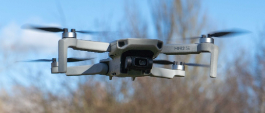
All these potential dangers must be considered while crime scene investigators examine and process a scene. One way to reduce risks to the investigator’s safety is the incorporation of drones into the documentation procedure for processing crime scenes.
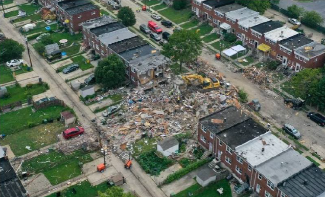
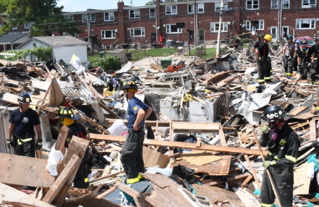
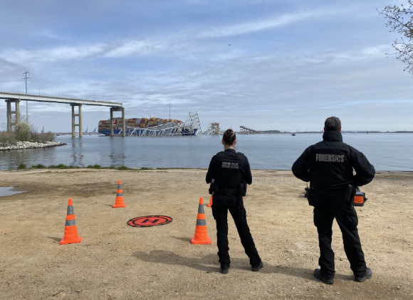
Forensic organizations, like Baltimore Police Department Crime Scene Unit, have successfully deployed drones on numerous scenes. In August 2020, the Baltimore Police Department Crime Scene Unit was sent to a gas explosion scene in northwest Baltimore where one woman died and seven people were seriously injured. The site was so hazardous that drones were deployed for safety reasons. Drones were also deployed when the Francis Scott Key Bridge collapsed in March 2024.
According to the Federal Aviation Administration (FAA), drones are referred to as small, unmanned aircraft that operate in federally navigable airspaces not directed by human intervention from within the aircraft. Under federal law, drones are considered an aircraft regardless of size or purpose. The use of drones in the National Airspace System is regulated and enforced by the FAA. To fly a drone under the 14 CFR Part 107- Small Unmanned Aircraft Systems, the operator(s) must obtain a Remote Pilot Certificate from FAA to proof understanding of regulations, operation requirements, and procedures for flying drones in a safe manner, including successfully passing the aeronautical knowledge examination.
Below is a summary of FAA’s rules and regulations regarding the operation of drones which include:
- All aircraft(s) under 55 pounds (25 kg) must be registered with the FAA
- Must fly in uncontrolled airspace only
- Must be flown in the visual line-of-sight
- Must fly under 400 feet above ground level
- Right of way must be given to manned aircraft(s)
- Use anti-collision lighting during flights at nighttime
- Must not fly over people
- Must not operate from a moving vehicle or aircraft
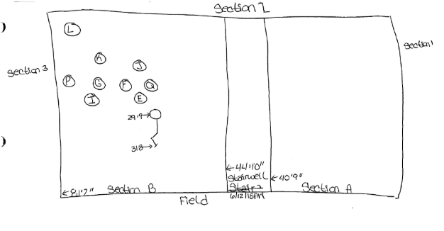
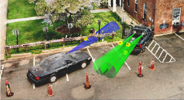
Drones can provide forensic organizations that offer crime scene services an efficient, safer, and cost-effective method of obtaining an accurate representation of the crime scenes. This is achieved by drone photogrammetry which captures overlapping aerial images recorded from different angles. Then the software program puts these images together creating orthomosaic maps, a 3D point cloud, and digital surface models.

The integration of drones used in conjunction with 3D laser scanners, such as FARO has revolutionized documentation of crime scenes by providing the most comprehensive information from the ground (terrestrial) and sky (aerial) viewpoints. The pairing of drones with a 3D laser scanner can also provide more precise measurements. Operators can also import photographs taken by the drone into the FARO Zone 3D Expert software to create 2D and 3D diagrams for documentation. This is an excellent resource for large outdoor crime scenes.
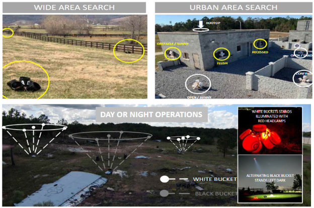
Prior to implementation, verification studies must be conducted to ensure validity of the results captured by the imaging equipment and the accuracy of measurements. Standard operating procedures must be created for the operation of the equipment, including equipment set-up, storage, maintenance, and relevant step-by-step instructions. Personnel assigned to operate the drones must successfully complete the training to become drone pilots and demonstrate competency. A log should be maintained to document flight time, maintenance, and any equipment issues.
Proficiency tests for the operation of drones should be successfully completed by drone pilots to monitor performance, validity, and quality. The National Institute of Standards and Technology (NIST) offers test methods for evaluating aerial drones to serve as proficiency tests for individual pilots and assess drone capabilities. These test methods have been standardized through the ASTM International Standards Committee on Homeland Security Applications.
In conclusion, as technology evolves, forensic service providers must ensure that they maintain public trust, comply with regulatory and statutory requirements, and implement a robust quality system which can be achieved through accreditation.
Want to learn more about A2LA’s Forensic Accreditation Program? Download our Forensic Program Handbook and get a comprehensive overview of the program, including program requirements, the assessment process, subprograms, transfer process, and more. Get your guide here: https://mktg.a2la.org/l/273522/2025-08-25/42ps8fq
Ready to take the next step toward becoming an A2LA accredited forensic lab? Request a quote today.
References
Federal Aviation Administration: https://www.faa.gov/uas
14 CFR Part 107- Small Unmanned Aircraft Systems
FARO: https://www.faro.com/en/Resource-Library/WebinarPresentation-Recording/FARO-Zone-3D-Expert-Software
NIST: https://www.nist.gov/el/intelligent-systems-division-73500/standard-test-methods-response-robots
NIST: Tests and Scorable Scenarios for Evaluating Drone Capabilities and Remote Pilot Proficiency in Open, Obstructed, and Confined Environments (Levels 1-5) Version 2023C
Descalzi, M.J. (2025, October). Utilizing Drones for Crime Scene Documentation [PowerPoint]. AFQAM Conference, Portland, Oregon, USA.
WBALTV News: https://www.wbaltv.com/article/baltimore-house-explosion-reisterstown-road/33562013